


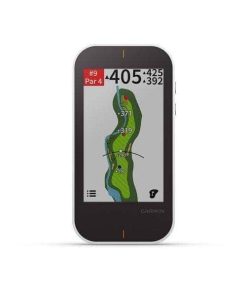
Overview
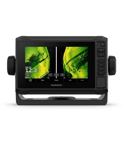
KNOW THE WATER BETTER THAN A LOCAL
When it comes to catching more fish, they say, “Talk to a local.” With the ECHOMAP UHD2 chartplotter, which offers our best-in-class sonar and mapping and premium touchscreen display with keyed-assist, you’ll know the water even better than they do.
-
The bright 6”, 7” or 9” touchscreen display with keyed-assist is user-friendly and easy to read.
- Good things come in threes. Three sonar types, that is: Garmin traditional, ClearVü™ and SideVü™ sonars.
- Improved detail? Check. Distinguished targets? Yep. That’s the beauty of high-contrast vivid color palettes.
- If you’re running another ECHOMAP UHD2 chartplotter, you can wirelessly share sonar, waypoints and routes.
- Want our best in mapping? Who doesn’t? Select chartplotters come with Garmin Navionics+™ mapping.

SONAR SUPPORT
With crisp, clear traditional sonar and brilliant ClearVü and SideVü scanning sonars, the fish will have nowhere to hide. Your ECHOMAP UHD2 also supports LiveScope™ live-scanning sonar.

VIVID COLOR PALETTES
High-contrast vivid scanning sonar color palettes make it easier than ever to distinguish targets and structure.
BUNDLE YOUR TRANSDUCER
Your ECHOMAP UHD2 device supports a variety of Garmin transducers. The 6” and 7” chartplotters come bundled with a GT54 transducer — while the 9” chartplotter comes with a GT54 transducer.

PRELOADED CHARTS
You’ve never seen Garmin cartography like this before. Select chartplotters come with built-in Garmin Navionics+ cartography which includes a 1-year subscription for daily updates, depth range shading and more.

WIRELESS NETWORKING
If you have another compatible ECHOMAP UHD2 chartplotter on your boat, you can wirelessly share information — such as sonar1, waypoints and routes — with them.

ACTIVECAPTAIN® APP
Built-in Wi-Fi® connectivity pairs with the free all-in-one mobile app on your compatible smartphone for access to the OneChart™ feature, smart notifications, software updates, Garmin Quickdraw™ Community data and more2.

AUTO GUIDANCE+™ TECHNOLOGY
Chartplotters with built-in Garmin Navionics+ charts include downloadable Auto Guidance+ technology3 with the ActiveCaptain app.

TROLL WITH FORCE®
Your ECHOMAP UHD2 wirelessly connects to your Force trolling motor to create and follow routes, navigate to waypoints, control speed, check battery life and more.

MULTI-BAND GPS
Get improved position accuracy, particularly in areas where signals are reflected or weak, with multi-band GPS.
Specs
General |
|
| DIMENSION | 8.1″ x 5.2″ x 2.6″ (20.6 x 13.1 x 6.7 cm) |
|---|---|
| TOUCHSCREEN | |
| INPUT | Touchscreen with Keyed Assist |
| DISPLAY SIZE | 5.4″ x 3.1″, 6.2″ (13.8 x 7.8, 15.7 cm) |
| DISPLAY RESOLUTION | 800 x 480 pixels |
| DISPLAY TYPE | WVGA, TN |
| WEIGHT |
1.8 lbs (0.8 kg) |
| WATERPROOF | IPX7 |
| MOUNTING OPTIONS | bail or flush |
Maps & Memory |
|
| ACCEPTS DATA CARDS |
1 microSD™ card; 32 GB maximum size |
|---|---|
| WAYPOINTS |
5,000 |
| TRACK POINTS | 50,000 |
| TRACKS | 50 saved tracks |
| NAVIGATION ROUTES | 100 |
Sensors |
|
| HAS BUILT-IN RECEIVER | |
|---|---|
| RECEIVER |
10 Hz |
| NMEA 2000 COMPATIBLE | |
| GPS | |
| GLONASS | |
| GALILEO | |
| BEIDOU | |
| SUPPORTS WAAS | |
| SUPPORTS MULTI-BAND, MULTI-CONSTELLATION GPS | |
Built-in Maps |
|
| BUILT-IN AUTO GUIDANCE+ | yes (downloadable via ActiveCaptain app) |
|---|---|
| GARMIN NAVIONICS+ INLAND & COASTAL | yes (see Additional) |
| GARMIN NAVIONICS+ (COASTAL) | yes (see Additional) |
| GARMIN NAVIONICS+ (INLAND) | yes (see Additional) |
| TIDE TABLES | yes (see Additional) |
Optional Map Support |
|
| GARMIN NAVIONICS+™ | |
|---|---|
| GARMIN NAVIONICS VISION+™ | |
| TOPO | |
| STANDARD MAPPING | |
| GARMIN QUICKDRAW CONTOURS | |
Chartplotter Features |
|
| AIS | |
|---|---|
| DSC | |
| SUPPORTS FUSION-LINK™ COMPATIBLE RADIOS | |
| ACTIVECAPTAIN® COMPATIBLE | |
| SAILING FEATURES | |
Sonar Features & Specifications |
|
| DISPLAYS SONAR | |
|---|---|
| POWER OUTPUT | 500 W |
| TRADITIONAL SONAR (DUAL FREQUENCY/BEAM) | built-in (single channel CHIRP, 50/77/83/200 kHz, L, M, H CHIRP) |
| CLEARVÜ | built-in 260/455/800/1000/1200 kHz |
| SIDEVÜ | built-in 260/455/800/1000/1200 kHz |
| PANOPTIX™ SONAR | |
| LIVESCOPE | |
Connections |
|
| NMEA 2000 PORTS | |
|---|---|
| GARMIN MARINE NETWORK PORTS |
1 |
| 12-PIN TRANSDUCER PORTS | 1 |
| BLUETOOTH® PAIRING | |
| ANT+ (CONNECTIVITY) | |
| GARMIN WI-FI NETWORK (LOCAL CONNECTION) | |
Electrical Features |
|
| POWER INPUT | 9 to 18 Vdc |
|---|---|
| TYPICAL CURRENT DRAW AT 12 VDC | 1.53 A |
| MAXIMUM CURRENT DRAW AT 12 VDC | 3.2 A |
| MAXIMUM POWER USAGE AT 10 VDC | 18.4W |
Additional |
|
| ADDITIONAL |
|
|---|---|
In The Box
With Transducer
- ECHOMAP UHD2 (device varies depending on selection)
- GT54-TM transducer
- Power cable
- Tilt/swivel mount with quick release cradle
- Protective cover
- Hardware
- Documentation
Without Transducer
- ECHOMAP UHD2 (device will vary depending on selection)
- 12-pin sounder to 8-pin transducer cable
- Power cable
- Tilt/swivel mount with quick release cradle
- Protective cover
- Hardware
- Documentation
| Type | With GT54UHD-TM Transducer and Garmin Navionics+ U.S. Inland Mapping |
|---|
Fast Shipping and Professional Packing
We offer a wide range of shipping options due to our long-standing relationships with UPS, FedEx and DHL. Our warehouse staff are extremely skilled and will package your items according to our precise and precise specifications. Your goods are thoroughly checked and securely secured prior to shipment. Everyday we deliver thousands of packages to clients from all over the world. The fact that we are dedicated to becoming the largest online retailer in the World is obvious. Warehouses and distribution centers can be found in Europe as well as in the USA.
Orders that include more than 1 item are assigned processing periods according to each item.
Before shipping, we will inspect the ordered items thoroughly. The majority of orders are delivered within 48 hours. Delivery is expected to take between 3 and seven days.
Returns
We are not able to manage the stock at our factory and warehouse. Therefore, the actual inventory could change at any time. It's possible that your order may become unfulfilled after you place the order.
Our policy lasts for a period of 30 days. However, if 30 days have passed since you purchased your item, we cannot offer you a return or exchange.
For your item to be considered eligible for return, it must be unopened and in the same state as you received it in. It must also be in the original packaging.
Related products


Uncategorized

Uncategorized

Uncategorized

Uncategorized

Uncategorized


Uncategorized

Uncategorized


Uncategorized

Uncategorized


Uncategorized

Uncategorized

Uncategorized

Uncategorized


Uncategorized

Uncategorized


Uncategorized

Uncategorized

Uncategorized


Uncategorized

Uncategorized

Uncategorized

Uncategorized

Uncategorized

Uncategorized

Uncategorized

Uncategorized